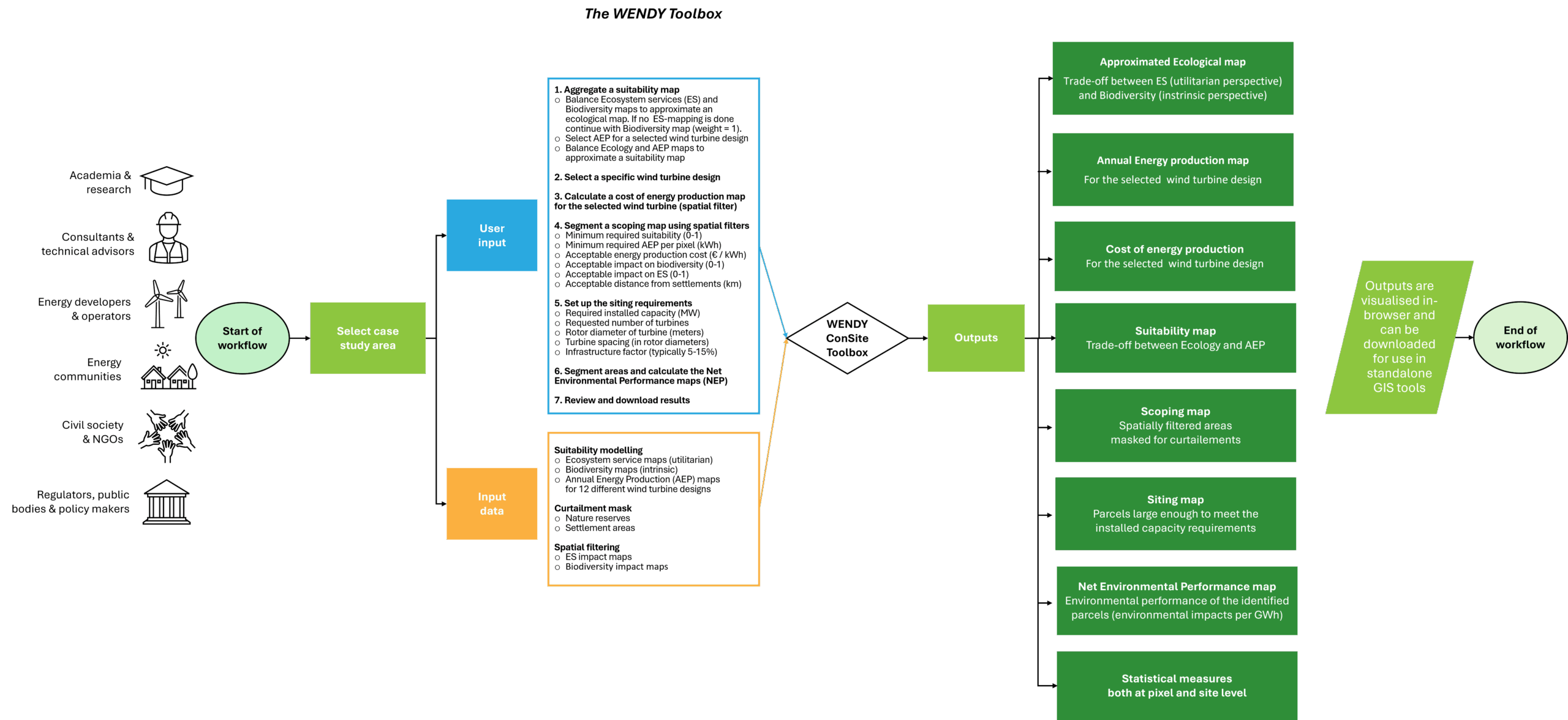
WENDY toolbox
The WENDY toolbox is a powerful spatial decision-support system developed within the WENDY project to optimize the scoping and siting of wind energy projects. It integrates technical, environmental, and social criteria to help planners identify the most suitable locations for wind farm development, balancing energy production potential with ecological preservation, masked for social acceptance and curtailments.
 Key features
-
Integrated spatial analysis: Combines technical, environmental, and social criteria for holistic site assessments.
-
Customizable trade-offs: Allows users to adjust the relative importance of ecological conservation and energy production.
-
Interactive mapping: Provides advanced geospatial visualization for detailed, data-driven siting decisions.
-
User-friendly interface: Streamlines complex data inputs and outputs for ease of use by both experts and non-experts.
Core components
-
Technical assessments: Evaluates wind resources, site accessibility, and infrastructure requirements.
-
Environmental impact: Assesses utilitarian and intrinsic nature values, habitat loss, and ecosystem disruptions using Potential Disappeared Fraction (PDF) values.
-
Social acceptance: Measures public perceptions through local stakeholder mapping of ecosystem services, potential conflicts, and impacts on local communities.
-
Economic feasibility: Calculates turbine specific annual energy potential (AEP), levelized cost of energy (LCOE) and project financial viability.
Why use the WENDY toolbox?
-
Comprehensive site evaluation: Balances technical, social, and environmental factors for optimal siting.
-
Data-driven decision support: Utilizes cloud sourced cutting-edge spatial analysis for accurate, transparent assessments.
-
Customizable for diverse projects: Adapts to various regional contexts and project goals, ensuring flexibility and scalability.
-
Support for ongoing assessments: Allows users to refine analyses as new data becomes available, supporting continuous project optimization.

How it works
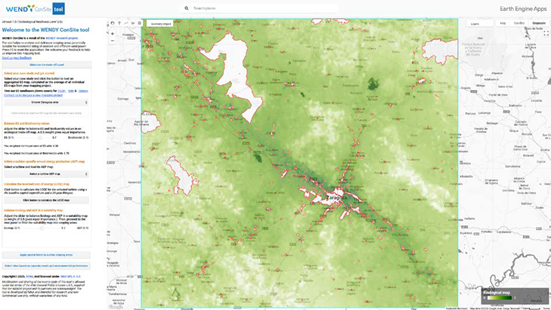
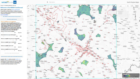
The tool is a web application developed in the Google Earth Engine Java API and uses the Google Cloud Platform for high-performance geospatial data processing. It consumes spatio-temporal datasets from NINA’s internal feature and image collections hosted on Google Cloud, including annual energy production layers, biodiversity layers, ecosystem services layers, LCOE, social constraint layers and curtailment layers. Inputs are provided via a JavaScript-based web interface; no user login is required, but users must manually adapt their browser zoom for optimal display. Users do not need to provide external data—all required inputs are pre-integrated and processed automatically based on user interaction with the map interface. More specifically, the WENDY toolbox requires the following user inputs:
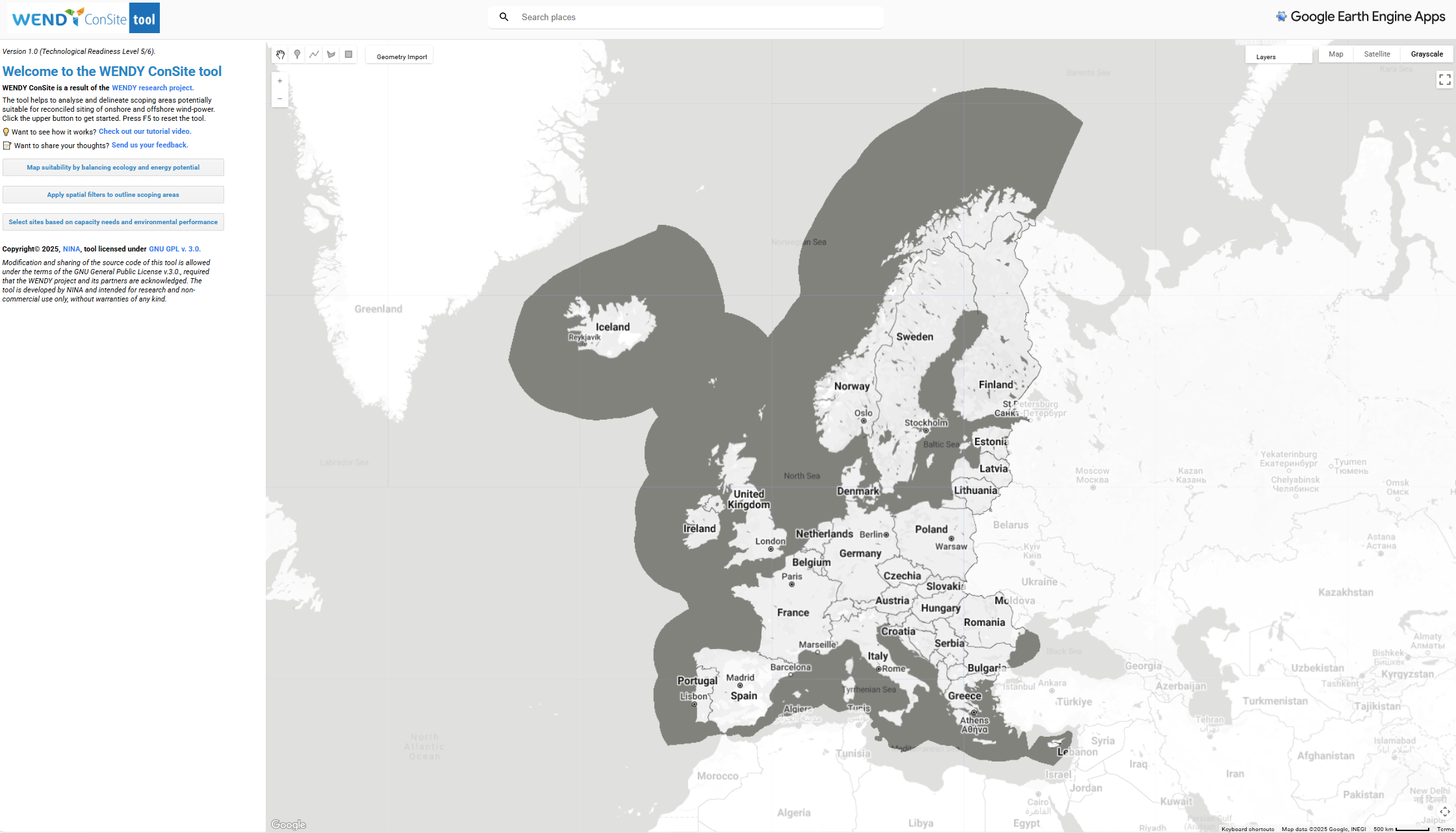
– Case study area: Users must first select a geographic region of interest (ROI), which will act as the geographic boundary for all subsequent analyses.
Please contact NINA if you would like to map a new case study area.
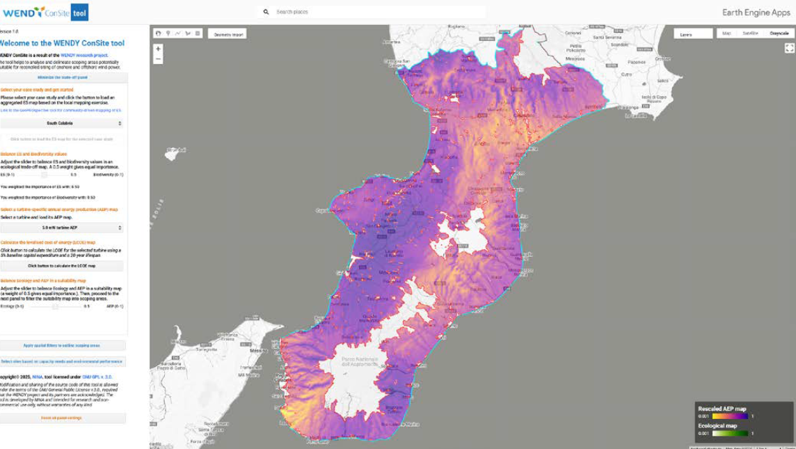
– Ecological Value Maps: Users are required to balance ecosystem services (ES) and biodiversity layers. This includes:
-
Ecosystem services (ES) map: Represents human-derived nature benefits, aggregated from stakeholder inputs.
-
Biodiversity map: Represents species richness and intrinsic natural value.
The weights for these layers can be adjusted to reflect local priorities (e.g., 70% biodiversity, 30% ES).
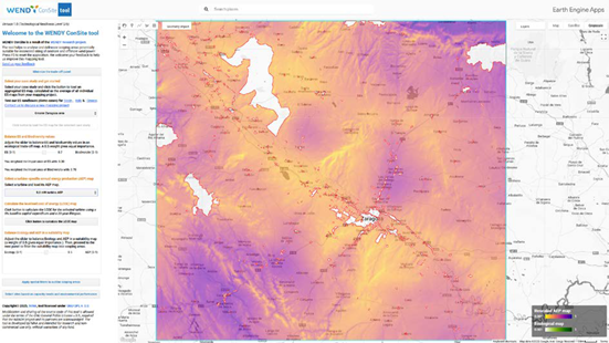
– Annual Energy Production (AEP) Map: Users must select a specific wind turbine model (e.g., 5 MW, 8.4 MW, 12 MW) and load the corresponding AEP map (in kWh/year) provided by CIRCE. This data is automatically rescaled to a 0–1 range for compatibility with ecological data.
– Cost assessment: Users must calculate the Levelized Cost of Energy (LCOE) for the selected wind turbine assuming a 5% baseline capital expenditure and a 20-year operational lifespan.
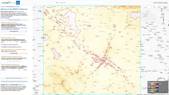
– Curtailment masks: Settlement areas and protected nature reserves are automatically masked out.
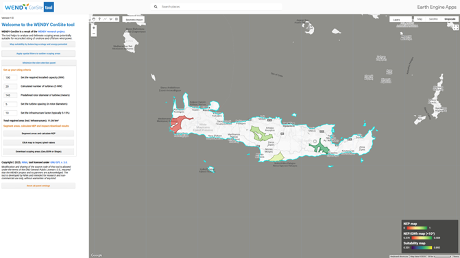
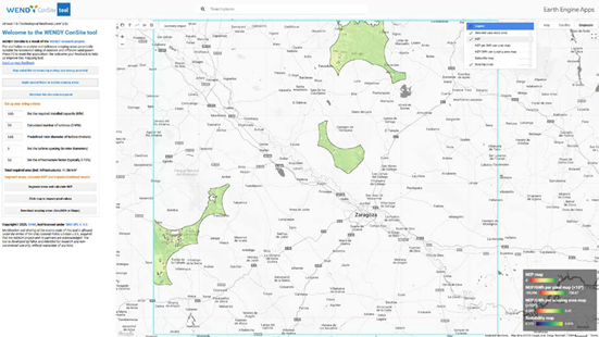
– Site constraints and capacity requirements: Users must set spatial filters, including:
-
Minimum required suitability
-
Minimum required AEP
-
Minimum acceptance for LCOE costs per kWh
-
Maximum acceptance for biodiversity impact
-
Maximum acceptance for impact on ES
-
Minimum distance from residential areas
-
Proximity to protected nature reserves
-
Installed capacity requirements (e.g., 100 MW total capacity, with individual turbine specifications such as rotor diameter and spacing rules).
-
Infrastructure factor (typically 5–15% additional land required for roads and facilities).
-
Environmental performance thresholds: Users must define acceptable thresholds for biodiversity impacts and ecosystem disruptions, using normalized PDF values from WP3 (0 to 1 scale).
The WENDY toolbox guides users through a stepwise workflow to assess potential wind farm sites:
1. Ecological balancing: Users first balance ES and biodiversity layers to generate a composite ecological value map.
2. Energy potential assessment: The user selects a turbine specific Annual Energy Production map (in KWh/year) to quantify the energy production potential of each site and then calculates a Levelized Cost of Energy map in €/kWh
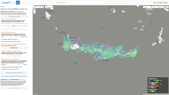
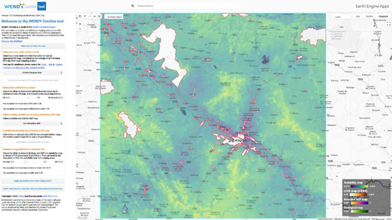
3. Suitability analysis: The tool then combines the ecological and AEP layers to produce a weighted suitability map, where high energy potential and low ecological impact areas are prioritized.
 4. Spatial filtering: Users refine the suitability map based on distance thresholds, installed capacity, and infrastructure factors.
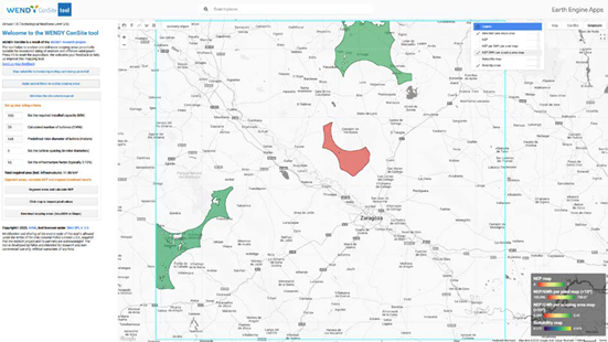
 5. Site selection: The final step involves defining the minimum parcel size needed to meet the specified capacity, using turbine spacing rules and buffer zones and calculate NEP per pixel.
 6. Environmental performance evaluation: The tool calculates Net Environmental Performance (NEP) values for each scoping area, providing a measure of environmental impact per GWh.
Outputs are visualised in-browser and can be downloaded as GeoTIFF, CSV, or shapefiles for use in standalone GIS or engineering tools.
The WENDY Toolbox represents a leap forward in sustainable spatial planning for wind energy projects. By combining technical precision, social insights, and environmental considerations, it ensures responsible decision-making at every step.
Flowchart
Explore the tool by clicking here: WENDY Toolbox
For more information about the WENDY toolbox please see the video below.
CONSORTIUM PARTNERS


